Himalayas
Himalayas
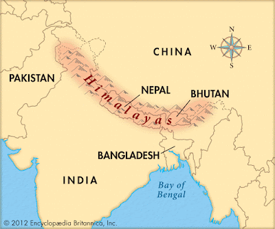
Map of Himalaya

Himalayas, Nepali Himalaya, great mountain system of Asia forming a barrier between the Plateau of Tibet to the north and the alluvial plains of the Indian subcontinent to the south.
Formations about Himalayas HD
The Himalayas include the highest mountains in the world, with more than 110 peaks rising to elevations of 24,000 feet (7,300 metres) or more above sea level.

One of those peaks is Mount Everest (Tibetan: Chomolungma; Chinese: Qomolangma Feng; Nepali: Sagarmatha), the world’s highest, with an elevation of 29,035 feet (8,850 metres; see Researcher’s Note: Height of Mount Everest. The mountains’ high peaks rise into the zone of perpetual snow.
For thousands of years the Himalayas have held a profound significance for the peoples of South Asia, as their literature, mythologies, and religions reflect.
For thousands of years the Himalayas have held a profound significance for the peoples of South Asia, as their literature, mythologies, and religions reflect.
Over the Himalayas
Since ancient times the vast glaciated heights have attracted the attention of the pilgrim mountaineers of India, who coined the Sanskrit name Himalaya—from hima (“snow”) and alaya (“abode”)—for that great mountain system.

In contemporary times the Himalayas have offered the greatest attraction and the greatest challenge to mountaineers throughout the world.
The ranges, which form the northern border of the Indian subcontinent and an almost impassable barrier between it and the lands to the north, are part of a vast mountain belt that stretches halfway around the world from North Africa to the Pacific Ocean coast of Southeast Asia.
The ranges, which form the northern border of the Indian subcontinent and an almost impassable barrier between it and the lands to the north, are part of a vast mountain belt that stretches halfway around the world from North Africa to the Pacific Ocean coast of Southeast Asia.

The Himalayas themselves stretch uninterruptedly for about 1,550 miles (2,500 km) from west to east between Nanga Parbat (26,660 feet [8,126 metres]), in the Pakistani-administered portion of the Kashmirregion, and Namjagbarwa (Namcha Barwa) Peak (25,445 feet [7,756 metres]), in the Tibet Autonomous Region of China.
Climat in Himalayas

Between those western and eastern extremities lie the two Himalayan countries of Nepal and Bhutan. The Himalayas are bordered to the northwest by the mountain ranges of the Hindu Kush and the Karakoram and to the north by the high and vast Plateau of Tibet.
The Himalayah HD
The width of the Himalayas from south to north varies between 125 and 250 miles (200 and 400 km). Their total area amounts to about 230,000 square miles (595,000 square km).
Though India, Nepal, and Bhutan have sovereignty over most of the Himalayas, Pakistan and China also occupy parts of them.
Though India, Nepal, and Bhutan have sovereignty over most of the Himalayas, Pakistan and China also occupy parts of them.

In the disputed Kashmir region, Pakistan has administrative control of some 32,400 square miles (83,900 square km) of the range lying north and west of the “line of control” established between India and Pakistan in 1972.
China administers some 14,000 square miles (36,000 square km) in the Ladakh district of Kashmir and has claimed territory at the eastern end of the Himalayas within the Indian state of Arunachal Pradesh.
The Himalayas from film Ultra..
Those disputes accentuate the boundary problems faced by India and its neighbours in the Himalayan region.


0 Comments